

A parcel can look perfectly buildable on an aerial image and become a very different project once flood boundaries, steep grades, poor soils, easements, transit access, and environmental constraints are placed on the same map.
That is the practical reason architects should learn how to use GIS for architectural site analysis. Geographic Information Systems turn scattered location data into a coordinated spatial model, allowing a design team to test what is possible before committing to a footprint, access strategy, or massing concept.
The important shift is simple: GIS does not merely describe a site. Used well, it exposes conflicts and opportunities that ordinary base maps hide.
Start With Questions, Not Layers
A common mistake is downloading every dataset available and producing a visually impressive map that answers no design question. Instead, define what the project needs to discover.
For an urban multifamily site, the questions might concern zoning, transit, surrounding heights, pedestrian access, heat exposure, flood risk, and adjacent land uses. A rural institutional project may need stronger analysis of slopes, soils, drainage, wildfire exposure, roads, and utility availability.
That distinction determines which datasets matter. At minimum, create an area of interest that extends beyond the property boundary. A building interacts with drainage networks, transportation systems, neighborhoods, solar exposure, vegetation, and infrastructure that do not stop at the parcel line.
Build a Reliable GIS Base Map
Before analyzing anything, make sure every dataset uses an appropriate coordinate reference system.
Architects often combine survey CAD drawings measured in feet with geographic datasets stored in latitude and longitude. If projections are handled incorrectly, measurements, buffers, or imported geometry can shift or distort.
For detailed U.S. site work, use an appropriate projected coordinate system such as the relevant State Plane or suitable UTM zone rather than performing area and distance calculations directly in geographic coordinates.
Then assemble the basic context: parcel boundaries, streets, buildings, aerial imagery, hydrography, property access points, and surrounding land uses.
The U.S. Census Bureau’s TIGER/Line GIS data contain roads, boundaries, hydrography, rails, and other geographic features. The Bureau’s current geodatabases are designed specifically for GIS use, although demographic information must be linked separately using geographic identifiers.
Read the Ground Before Drawing the Building

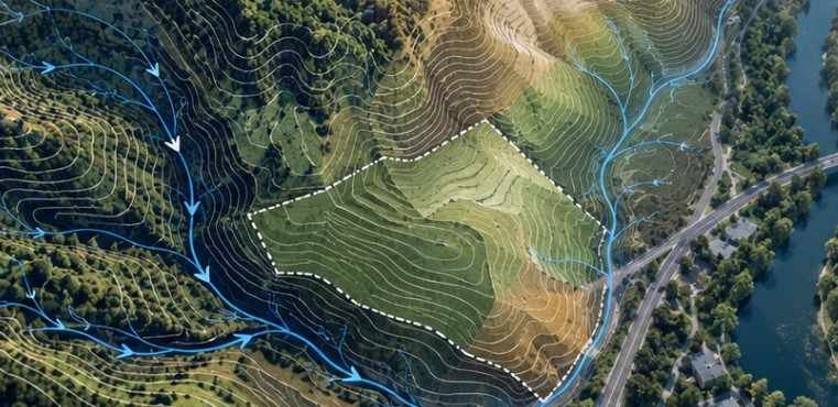
Topography is one of GIS’s most useful contributions to architectural site analysis. The USGS National Map provides free, nationally consistent geographic data, including elevation from the 3D Elevation Program. USGS offers digital elevation models at several resolutions, including 1-meter products where available.
Load a digital elevation model into QGIS or ArcGIS Pro and derive:
- elevation contours;
- slope;
- aspect;
- hillshade;
- low points and drainage direction.
These outputs immediately improve early decisions. A steep portion of a parcel may raise excavation costs, while a natural bench may offer a logical building location. Aspect can indicate areas with stronger southern exposure, and flow modeling can reveal where runoff naturally concentrates.
Do not treat GIS elevation as a replacement for a professional boundary or topographic survey. It is a screening and planning tool; construction documents still require project-appropriate surveyed information.
Map Water, Flooding, and Soil Conditions
Flood analysis deserves its own layer rather than being treated as a footnote.
FEMA describes its National Flood Hazard Layer as a geospatial database containing effective flood hazard mapping. The Flood Map Service Center is FEMA’s official public source for National Flood Insurance Program flood hazard information.
Overlay the property with flood zones, floodways, watercourses, and relevant elevation information. The result can influence finished-floor elevations, entrances, parking placement, landscape strategy, and whether part of the parcel should remain undeveloped.
Soils matter just as much. USDA’s Web Soil Survey provides current soil information and lets users download spatial, tabular, and thematic data for GIS analysis.
Soil mapping can flag conditions worth investigating—such as drainage limitations, shallow bedrock, shrink-swell potential, or other development considerations—but it does not eliminate geotechnical testing.
Add Regulations and Human Context

Physical suitability is only half the problem. A flat, dry parcel can still be unusable because of zoning or legal constraints.
Add local GIS layers for zoning districts, overlays, historic districts, setbacks, easements, rights-of-way, height limits, and environmentally protected areas wherever authoritative data are available.
Then examine the surrounding community.
Census geography can connect spatial boundaries with population, housing, and demographic data, helping teams study neighborhood context rather than treating the parcel as an isolated object.
For environmental context, EPA’s EnviroAtlas environmental GIS data provides more than 500 data layers covering ecosystem services and related environmental conditions, with national-scale information and finer-resolution datasets for selected populated places.
These layers can support analysis of vegetation, impervious surfaces, ecological conditions, environmental exposure, and green infrastructure opportunities.
Turn the Layers Into a Site-Suitability Model
The most valuable GIS analysis does not stop with overlays. It converts them into decisions.
A simple weighted suitability model might work like this:
| Criterion | Example GIS Treatment | Design Meaning |
| Slope | Reclassify from low to high | Flatter areas score higher |
| Flood exposure | Exclusion or penalty zone | Avoid vulnerable footprints |
| Road access | Distance buffer | Favor accessible locations |
| Soil limitation | Ranked classes | Penalize difficult ground |
| Transit access | Walking-distance buffer | Reward connected areas |
| Existing vegetation | Preservation constraint | Protect valuable landscape |
First, convert each criterion to a common scoring scale, such as 1 to 5. Then assign weights based on project priorities.
A flood-sensitive facility might give flood exposure a much greater weight than transit proximity. A transit-oriented housing project could reverse that relationship.
The final raster does not “choose” the architecture. It shows where competing conditions overlap favorably so the design team can investigate those zones first.
A Six-Step GIS Test for Any Site
Before schematic design, confirm that your GIS model can answer six questions:
- Where can development physically occur?
- Which areas face flood, drainage, slope, or soil problems?
- What regulatory boundaries restrict the envelope?
- How do people, roads, transit, and utilities reach the site?
- Which environmental assets should be protected?
- What information still requires field verification?
If the map cannot answer those questions, it is probably still a presentation drawing rather than an analytical tool.
Move GIS Intelligence Into the Design Model
Once the major constraints are understood, simplify the GIS information before importing it into Rhino, Grasshopper, Revit, Autodesk Forma, or another design environment.
Export only what matters: terrain, parcel geometry, streets, water, critical setbacks, contextual buildings, vegetation boundaries, or selected analysis zones.
Too much raw GIS information can make design files unnecessarily heavy.
This transition also becomes important later in digital production. Geographic context can inform early geometry, while disciplined model development supports downstream processes such as BIM-to-fabrication workflows and more specialized digital timber joinery methods.The key is maintaining clear units, coordinate origins, data dates, and sources during every transfer.
Where GIS Can Mislead Architects
GIS creates precision-looking maps, but precision on screen does not guarantee accuracy on the ground. Parcel datasets can lag behind legal records. Flood maps can change. Municipal zoning portals may omit recent amendments. Building footprints may be generalized, and utility locations are often unavailable or unsuitable for engineering decisions.
Every critical layer should therefore carry metadata: source, publication date, scale or resolution, coordinate system, and known limitation.
Treat GIS as evidence for asking better questions—not authority for skipping surveys, engineering studies, zoning confirmation, or site visits.
Frequently Asked Questions
1. What GIS software is best for architectural site analysis?
QGIS is a capable open-source option. ArcGIS Pro offers extensive professional analysis tools. The better choice depends on available datasets, office workflows, licensing, and required integrations.
2. Can GIS replace an architectural site survey?
No. GIS is excellent for regional and preliminary analysis, but property boundaries, construction elevations, utilities, and other critical conditions generally require qualified survey or engineering verification.
3. What GIS layers should architects collect first?
Start with parcels, aerial imagery, terrain, roads, hydrography, flood hazards, zoning, soils, surrounding buildings, and environmental constraints. Add project-specific datasets only after defining the decisions they must support.
4. How accurate should GIS data be for site planning?
Accuracy should match the decision being made. Regional datasets may support early feasibility work, while detailed design decisions require higher-resolution and professionally verified site information.
From Maps to Better Architectural Decisions
The real advantage of how to use GIS for architectural site analysis is not producing more diagrams. It is discovering problems while they are still cheap to solve.
A GIS model can reveal that the apparently obvious building pad conflicts with drainage, that a different entrance improves connectivity, or that preserving one portion of the site simplifies development elsewhere.
I would use GIS before serious massing begins, document every source, and then verify the conditions that materially affect design. The earlier spatial evidence enters the process, the less architecture has to fight the site later.